| Gateway
to America Route 23 in North Jersey |
|
| Scenery • Geography • Maps • Bears • Birds • Recreation |
|
|||||||||||
|
Some people may say that America starts when
you cross the Delaware River, but the gateway to America is Route
23 in New Jersey.
Route 23 in New Jersey begins (or ends, depending on your viewpoint) in the community of Verona, New Jersey between the First and Second Watchung Mountains. At the Junction of Route 506 (Bloomfield Avenue), Route 23 is named Pompton Avenue. Nearby is Caldwell, the birthplace of Grover Cleveland and Orange, the location of the Thomas Edison National Historic site. Bloomfield College, Seton Hall University, Montclair State University and Caldwell College are all located in this general area. A short distance away is Eagle Rock Reservation which has spectacular views of the New York City skyline. |
|||||||||||
|
This is the Northern Piedmont ecoregion comprised of irregular plains with low to moderately high hills and tablelands .The Piedmont plateau is separated from the Atlantic Coastal plain by the fall line that extends from Trenton to Newark Bay. It is a mixture of farmland and urban areas. Route 23's southern end is in the Piedmont Plateau which is underlain by beds of red sandstone and shale with layers of volcanic basalt. It is a region of low relief about 30 to 150 m (100 to 500 ft.) in elevation. The Watchung Mountains in the north of this region rise about 60 to 90 m (200 to 300 ft) above the general surface level. Route 23 proceeds through this area past giant shopping malls and small town main streets. Shortly after this busy road intersection, Route 23 becomes a pleasant tree-lined thoroughfare. Residential homes and small businesses, including a small shopping center, line the highway. It Narrows to a single lane through Cedar Grove's shopping district and then becomes two lanes again in an uphill straight-away along the shoulder of the Second Watchung Mountain. |
|||||||||||
Route 23 then descends into busy intersection in Singac, locally known as "Four Corners" at Fairfield Road, near the Passaic River. The word "Singac" translates to "Bog Meadow" in the ancient Leni Lenape language. Many of the areas continue to carry names from the Lenape and Minsi languages as well as Dutch. Crossing the Passaic River, the roadway skirts the Great Piece Meadows. Routes 80 and 46 meet with Route 23 in this area with a large shopping mall at the junction. |
|||||||||||
| Route 23 then continues along the edge of the Bog and Vly Meadow near Mountain View and Wayne. Many rivers converge in this area including the Passaic, Pompton, Ramapo and Pequannock. Here, the Piedmont plateau meets the New England Upland, locally known as the Reading Prong or New Jersey Highlands. The Reading Prong stretches from Connecticut to the Reading Hills in Pennsylvania. This area is made up of mostly metamorphic rocks such as gneiss and schist. It rises steeply in mountains such as Pohatcong, Scotts and Sparta. Broad flat plains of hardwood and evergreen forests are situated between the ridges and there are many lakes in the region. |
|
||||||||||
Immediately beyond the New Jersey Highlands is asection of the Appalachian Valley and Ridge region that lies in NW NJ. After the Highlands is a part of the great valley, known locally as the Kittatinny Valley some 24 km wide (15 mi) and underlain by limestone or sandstone and shale. The Kittatinny Mountains, a flat-topped sedimentary ridge containing some of the highest elevations in the statefollow the valley. The scenic Delaware Water Gap is situated where the Delaware River flows through these mountains. This cleft is 1200 ft deep in parts and less than one mile across. The cutting of the gap began in the Silurian Epoch with the formation of the rocks. This was broad flat plain through which meandered the Delaware River. Later, as land shifted along a fault line, the land became steeper and the river ran faster. The fast moving water along with sediment and stone caught in the current cut through the soft sedimentary rock creating the deep channel which can be seen today. .A glacier covered this area at the beginning of the Quaternary Period over 1000 feet thick. Evidence of it's passing can be found on the tops of the Kittantiny Mountains. |
|||||||||||
|
|||||||||||
|
Many parks and wildlife management areas are found in northern New Jersey. North of Route 23, from east to west, are Campgaw Mountain County Reservation, Ringwood State Park, Norvin Green State Forest, Abraham Hewitt State Forest, Wawayanda State Park, with High Point State Park straddling the highway. |
|||||||||||
Between Route 23 and the Raritan River in the south, many more such areas can be found. These include Stokes State Forest, Worthington State Forest, Swartswood State Park, Allamuchy Mountain Park, Farny State Park, Round Valley State Recreation Area, The Great Swamp National Wildlife Refuge as well as many smaller parks. In this area, the Pequest Wildlife Management Area and Trout Hatchery are located. |
|||||||||||
| Before it ends in Port Jervis, New York, Route 23 passes through High Point State park, one of an interconnecting trio of state parks including Stokes State Forest and Worthington State Forest to the south. These areas, among others, comprise the Delaware Water Gap National Recreation Area. | |||||||||||
|
Other Links
|
|
||||||||||
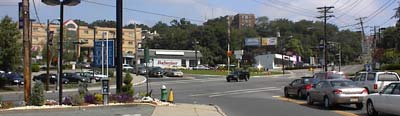 Southern
end of Route 23 intersecting Bloomfield Avenue (Route 506)
in Verona, New Jersey
Southern
end of Route 23 intersecting Bloomfield Avenue (Route 506)
in Verona, New Jersey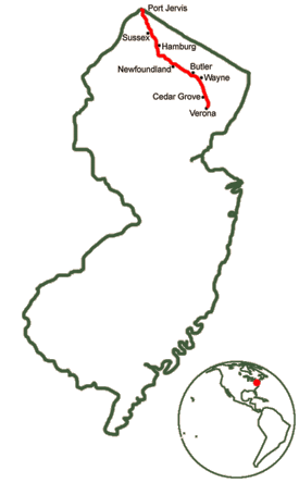

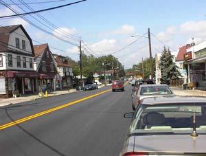 Cedar Grove business district on Route
23
Cedar Grove business district on Route
23 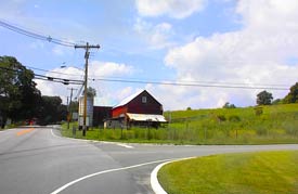 Small dairy farm in the Kittatinny Mountains
near Sussex, New Jersey
Small dairy farm in the Kittatinny Mountains
near Sussex, New Jersey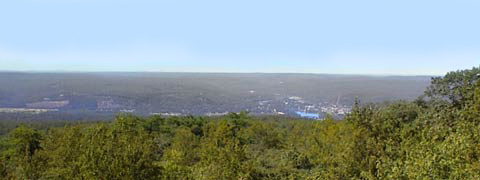 Delaware Water Gap National Recreation
Area and Port Jervis, New York viewed from atop the Kittatinny
Mountains at High Point
Delaware Water Gap National Recreation
Area and Port Jervis, New York viewed from atop the Kittatinny
Mountains at High PointHome • Scenery • History • Recreation • Home & Garden • Directory • Calendar • Classified Ads
• Maps • Scenery • Shopping
Advertise on rt23.com!
• Link to rt23.com!

Questions, comments, corrections? contact the Webmaster